
Reutlingen topographic map
Interactive map
Click on the map to display elevation.
About this map
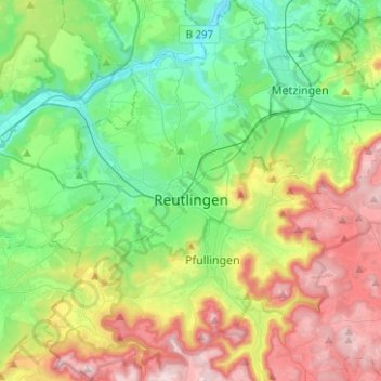
Name: Reutlingen topographic map, elevation, terrain.
Location: Reutlingen, Landkreis Reutlingen, Baden-Württemberg, Germany (48.41268 9.11487 48.57861 9.25559)
Average elevation: 1,601 ft
Minimum elevation: 948 ft
Maximum elevation: 2,812 ft
Other topographic maps
Click on a map to view its topography, its elevation and its terrain.
Engstingen
Germany > Baden-Württemberg > Landkreis Reutlingen
Engstingen is located on the northern edge of the Swabian Jura, at 680–750 metres (2,230–2,460 ft) altitude on the Alb plateau near the Alb edge in the valley of Ur-Lauter, about 15 km south of the town Reutlingen.
Average elevation: 2,421 ft
Kleinengstingen
Germany > Baden-Württemberg > Landkreis Reutlingen > Kleinengstingen
Average elevation: 2,395 ft