Tukums topographic map
Interactive map
Click on the map to display elevation.
About this map
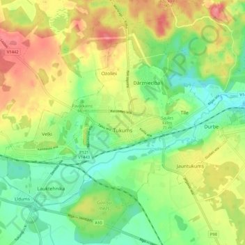
Name: Tukums topographic map, elevation, terrain.
Location: Tukums, Tukuma novads, Courland, Latvia (56.94949 23.10146 56.98798 23.20560)
Average elevation: 197 ft
Minimum elevation: 85 ft
Maximum elevation: 341 ft
Other topographic maps
Click on a map to view its topography, its elevation and its terrain.
Kolka
Latvia > Courland > Talsu novads > Kolkas pagasts
Kolka, Kolkas pagasts, Talsu novads, Courland, Latvia
Average elevation: 10 ft
Līkupēni
Latvia > Courland > Saldus novads > Rubas pagasts
Līkupēni, Rubas pagasts, Saldus novads, Courland, LV-3892, Latvia
Average elevation: 262 ft
Ragaciems
Latvia > Courland > Tukuma novads
Ragaciems, Tukuma novads, Courland, Latvia
Average elevation: 7 ft
Engure
Latvia > Courland > Ventspils novads
Engure, Ventspils novads, Courland, Latvia
Average elevation: 75 ft
Engure
Latvia > Courland > Ventspils novads
Engure, Kalnenieki, Ventspils novads, Courland, Latvia
Average elevation: 82 ft
Alsunga
Latvia > Courland > Kuldīgas novads > Alsungas pagasts
Alsunga, Alsungas pagasts, Kuldīgas novads, Courland, LV-3306, Latvia
Average elevation: 115 ft
Priekules novads
Priekules novads, Courland, LV-3434, Latvia
Average elevation: 197 ft
Engures novads
Latvia > Courland > Tukuma novads
Engures novads, Tukuma novads, Courland, Latvia
Average elevation: 75 ft
Pāvilosta
Latvia > Courland > Dienvidkurzemes novads
Pāvilosta, Dienvidkurzemes novads, Courland, LV-3466, Latvia
Average elevation: 26 ft