
Distrito Tolé topographic map
Interactive map
Click on the map to display elevation.
About this map
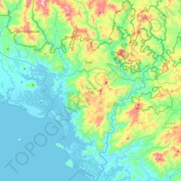
Name: Distrito Tolé topographic map, elevation, terrain.
Location: Distrito Tolé, Chiriquí, Panama (8.00088 -81.81733 8.37033 -81.51150)
Average elevation: 600 ft
Minimum elevation: -10 ft
Maximum elevation: 2,723 ft
Other topographic maps
Click on a map to view its topography, its elevation and its terrain.
Embalse Río Caldera
Panama > Chiriquí > Distrito de Boquete > Alto Boquete
Average elevation: 3,537 ft