
Distrito Gualaca topographic map
Interactive map
Click on the map to display elevation.
About this map
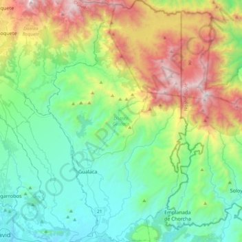
Name: Distrito Gualaca topographic map, elevation, terrain.
Location: Distrito Gualaca, Chiriquí, Panama (8.42625 -82.36053 8.78735 -82.12483)
Average elevation: 2,129 ft
Minimum elevation: 49 ft
Maximum elevation: 7,323 ft
Other topographic maps
Click on a map to view its topography, its elevation and its terrain.
Embalse Río Caldera
Panama > Chiriquí > Distrito de Boquete > Alto Boquete
Average elevation: 3,537 ft