
Distrito San Lorenzo topographic map
Interactive map
Click on the map to display elevation.
About this map
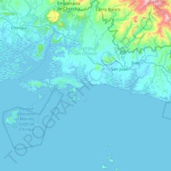
Name: Distrito San Lorenzo topographic map, elevation, terrain.
Location: Distrito San Lorenzo, Chiriquí, Panama (7.94462 -82.32076 8.48414 -81.94114)
Average elevation: 210 ft
Minimum elevation: -3 ft
Maximum elevation: 4,177 ft
Other topographic maps
Click on a map to view its topography, its elevation and its terrain.
Embalse Río Caldera
Panama > Chiriquí > Distrito de Boquete > Alto Boquete
Average elevation: 3,537 ft