
Distrito Boquerón topographic map
Interactive map
Click on the map to display elevation.
About this map
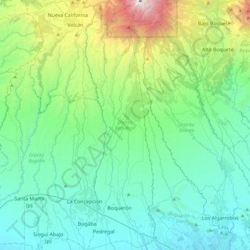
Name: Distrito Boquerón topographic map, elevation, terrain.
Location: Distrito Boquerón, Chiriquí, Panama (8.44889 -82.62303 8.80893 -82.51897)
Average elevation: 2,316 ft
Minimum elevation: 95 ft
Maximum elevation: 11,227 ft
Other topographic maps
Click on a map to view its topography, its elevation and its terrain.
Embalse Río Caldera
Panama > Chiriquí > Distrito de Boquete > Alto Boquete
Average elevation: 3,537 ft