
Distrito Tierras Altas topographic map
Interactive map
Click on the map to display elevation.
About this map
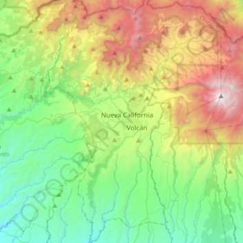
Name: Distrito Tierras Altas topographic map, elevation, terrain.
Location: Distrito Tierras Altas, Chiriquí, Panama (8.64456 -82.74164 8.91501 -82.54239)
Average elevation: 4,793 ft
Minimum elevation: 1,614 ft
Maximum elevation: 11,243 ft
Other topographic maps
Click on a map to view its topography, its elevation and its terrain.
Embalse Río Caldera
Panama > Chiriquí > Distrito de Boquete > Alto Boquete
Average elevation: 3,537 ft