
Distrito Barú topographic map
Interactive map
Click on the map to display elevation.
About this map
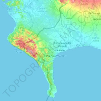
Name: Distrito Barú topographic map, elevation, terrain.
Location: Distrito Barú, Chiriquí, Panama (8.01227 -83.05172 8.59569 -82.70162)
Average elevation: 174 ft
Minimum elevation: 0 ft
Maximum elevation: 2,316 ft
Other topographic maps
Click on a map to view its topography, its elevation and its terrain.
Embalse Río Caldera
Panama > Chiriquí > Distrito de Boquete > Alto Boquete
Average elevation: 3,537 ft