
Campos Gerais topographic map
Interactive map
Click on the map to display elevation.
Campos Gerais
Campos Gerais is a municipality in the south of the Brazilian state of Minas Gerais. The population was 28,842 in 2020 in a total area of 769 km². The elevation is 1,026 m. It became a municipality in 1901.
About this map
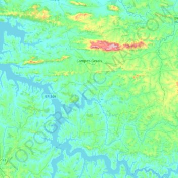
Name: Campos Gerais topographic map, elevation, terrain.
Average elevation: 2,749 ft
Minimum elevation: 2,484 ft
Maximum elevation: 4,209 ft
Other topographic maps
Click on a map to view its topography, its elevation and its terrain.
Belo Horizonte
Brazil > Minas Gerais > Região Metropolitana de Belo Horizonte > Belo Horizonte
In 1893, due to the climatic and topographic conditions, Curral Del Rey was selected by Minas Gerais governor Afonso Pena among other cities as the location for the new economic and cultural center of the state, under the new name of Cidade de Minas, or City of Minas.
Average elevation: 2,966 ft
São Vicente
Brazil > Minas Gerais > Região Integrada de Desenvolvimento do Distrito Federal e Entorno > Buritis > São Vicente
Average elevation: 2,116 ft
Unaí
Brazil > Minas Gerais > Região Integrada de Desenvolvimento do Distrito Federal e Entorno > Unaí > Unaí
Average elevation: 1,939 ft