
Deadwood topographic map
Interactive map
Click on the map to display elevation.
Deadwood
Deadwood is characterized by its rugged terrain nestled within the Black Hills region, boasting an elevation of approximately 4,531 feet. The town itself is set in a steep, narrow gulch surrounded by densely forested hills, which create a dramatic landscape of rolling hills and rocky outcrops. The topography features a mix of steep inclines and valleys, making it an ideal setting for outdoor activities like hiking and wildlife observation. The surrounding area is rich in natural beauty, with various trails that weave through the Black Hills National Forest, showcasing diverse flora and fauna, including deer and bighorn sheep. This unique geography not only contributes to the town's charm but also plays a significant role in its historical development during the Gold Rush era.
About this map
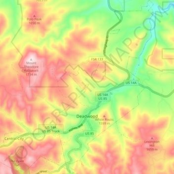
Name: Deadwood topographic map, elevation, terrain.
Average elevation: 4,957 ft
Minimum elevation: 4,150 ft
Maximum elevation: 5,692 ft
Lawrence County trails, hiking, mountain biking, running and outdoor activities
Other topographic maps
Click on a map to view its topography, its elevation and its terrain.