
Maggie Valley topographic map
Interactive map
Click on the map to display elevation.
About this map
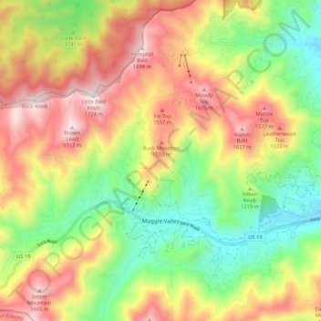
Name: Maggie Valley topographic map, elevation, terrain.
Location: Maggie Valley, Haywood County, North Carolina, United States (35.50322 -83.11040 35.56502 -83.00542)
Average elevation: 4,091 ft
Minimum elevation: 2,782 ft
Maximum elevation: 5,627 ft
Haywood County trails, hiking, mountain biking, running and outdoor activities
Other topographic maps
Click on a map to view its topography, its elevation and its terrain.
Panther Creek
United States > North Carolina > Haywood County > Panther Creek
Average elevation: 2,864 ft