
Bass Lake topographic map
Interactive map
Click on the map to display elevation.
About this map
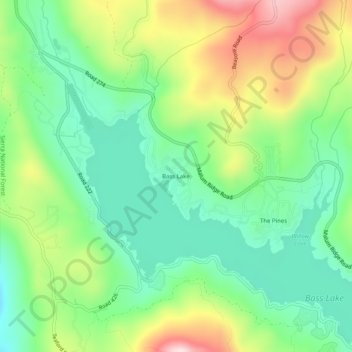
Name: Bass Lake topographic map, elevation, terrain.
Location: Bass Lake, Madera County, California, 93604, United States (37.30467 -119.58625 37.34467 -119.54625)
Average elevation: 3,635 ft
Minimum elevation: 3,189 ft
Maximum elevation: 4,419 ft
Madera County trails, hiking, mountain biking, running and outdoor activities
Other topographic maps
Click on a map to view its topography, its elevation and its terrain.
Ansel Adams Wilderness
United States > California > Madera County
The Ansel Adams wilderness spans in elevation from 3,500 to 13,157 feet (1,067 to 4,010 m), forming the northern end of the High Sierra.
Average elevation: 8,222 ft
Chowchilla
United States > California > Madera County
Chowchilla is a city in Madera County, California, United States. The city's population was 19,039 at the 2020 census. Chowchilla is located 16 miles (26 km) northwest of Madera, at an elevation of 240 feet (73 m).
Average elevation: 230 ft