
Karzok topographic map
Interactive map
Click on the map to display elevation.
About this map
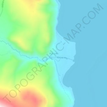
Name: Karzok topographic map, elevation, terrain.
Location: Karzok, Leh Tehsil, Leh district, Ladakh, India (32.94613 78.24299 32.98613 78.28299)
Average elevation: 15,151 ft
Minimum elevation: 14,823 ft
Maximum elevation: 16,316 ft
Other topographic maps
Click on a map to view its topography, its elevation and its terrain.
Tso Moriri
India > Ladakh > Leh Tehsil > Karzok
Tso Moriri, Karzok, Leh Tehsil, Leh district, Ladakh, India
Average elevation: 16,549 ft