
Make a donation
Gear up for your next adventure:
As an Amazon Associate, this site earns from qualifying purchases at no extra cost to you.
Staten Island topographic map
Click on the map to display elevation.
Make a donation
Gear up for your next adventure:
As an Amazon Associate, this site earns from qualifying purchases at no extra cost to you.
Staten Island
Although Staten Island is a borough of New York City, the island is topographically and geologically a part of New Jersey. Staten Island is separated from Long Island by the Narrows and from mainland New Jersey by the Arthur Kill and the Kill Van Kull. Staten Island is positioned at the center of New York Bight, a sharp bend in the shoreline between New Jersey and Long Island. The region is considered vulnerable to sea-level rise. On October 29, 2012, the island experienced severe damage and loss of life along with the destruction of many homes during Hurricane Sandy.
Make a donation
Gear up for your next adventure:
As an Amazon Associate, this site earns from qualifying purchases at no extra cost to you.
About this map
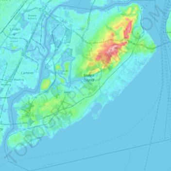
Name: Staten Island topographic map, elevation, terrain.
Location: Staten Island, Richmond County, New York, United States (40.47658 -74.25884 40.65151 -74.03461)
Average elevation: 30 ft
Minimum elevation: -16 ft
Maximum elevation: 397 ft
New York trails, hiking, mountain biking, running and outdoor activities
Make a donation
Gear up for your next adventure:
As an Amazon Associate, this site earns from qualifying purchases at no extra cost to you.
Other topographic maps
Click on a map to view its topography, its elevation and its terrain.
Make a donation
Gear up for your next adventure:
As an Amazon Associate, this site earns from qualifying purchases at no extra cost to you.
Make a donation
Gear up for your next adventure:
As an Amazon Associate, this site earns from qualifying purchases at no extra cost to you.
Flushing Meadows-Corona Park
United States > New York > New York
Around 1907, contractor Michael Degnon, whose firm constructed the Williamsburg Bridge, the Cape Cod Canal, and the Steinway subway tunnel (used by today's 7 and <7> trains), purchased large tracts of marsh near Flushing Creek. At the time, the land was considered "all but worthless". Degnon envisioned…
Average elevation: 49 ft
Make a donation
Gear up for your next adventure:
As an Amazon Associate, this site earns from qualifying purchases at no extra cost to you.
Make a donation
Gear up for your next adventure:
As an Amazon Associate, this site earns from qualifying purchases at no extra cost to you.
Make a donation
Gear up for your next adventure:
As an Amazon Associate, this site earns from qualifying purchases at no extra cost to you.