
Anacortes topographic map
Interactive map
Click on the map to display elevation.
About this map
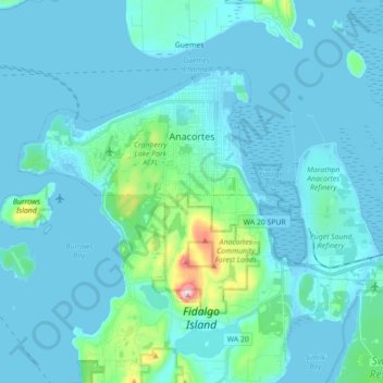
Name: Anacortes topographic map, elevation, terrain.
Location: Anacortes, Skagit County, Washington, 98221, United States (48.44799 -122.70417 48.52243 -122.52789)
Average elevation: 118 ft
Minimum elevation: -7 ft
Maximum elevation: 1,250 ft
Skagit County trails, hiking, mountain biking, running and outdoor activities
Other topographic maps
Click on a map to view its topography, its elevation and its terrain.
Skyline Home Owners Association
United States > Washington > Skagit County > Anacortes
Average elevation: 46 ft
Black Peak
United States > Washington > Skagit County
Black Peak is a tall peak in the Cascade Range in the U.S. state of Washington. It lies in the Stephen Mather Wilderness and North Cascades National Park. At 8,975 feet (2,736 m) in elevation it is the 20th-highest peak in Washington. Black Peaks's prominence is 3,450 feet (1,050 m), making it the 35th-most…
Average elevation: 6,883 ft
Anacortes
United States > Washington > Skagit County > Anacortes > Anacortes
Average elevation: 121 ft