
South Downs National Park topographic map
Interactive map
Click on the map to display elevation.
South Downs National Park
The South Downs National Park's chalk downland sets it apart from other national parks in Britain. However, almost a quarter (23%) of the national park consists of a quite different and strongly contrasting physiographic region, the western Weald, whose densely wooded hills and vales are based on an older Wealden geology of resistant sandstones and softer clays. The highest point in the national park, Blackdown, at 280 m (919 ft) above sea level, is in fact situated in the Weald, on the Greensand Ridge, whereas the highest point on the chalk escarpment of the South Downs, Butser Hill, has an elevation of 271 m (889 ft) above sea level.
About this map
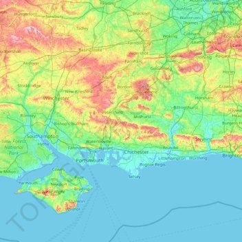
Name: South Downs National Park topographic map, elevation, terrain.
Location: South Downs National Park, West Sussex, England, United Kingdom (50.73324 -1.33670 51.19341 0.27259)
Average elevation: 177 ft
Minimum elevation: -10 ft
Maximum elevation: 974 ft
Other topographic maps
Click on a map to view its topography, its elevation and its terrain.
Smock Alley
United Kingdom > England > West Sussex > Horsham > West Chiltington
Average elevation: 125 ft
Donnington Park
United Kingdom > England > West Sussex > Chichester > Apuldram
Average elevation: 26 ft
Wickhurst Green
United Kingdom > England > West Sussex > Horsham > Wickhurst Green
Average elevation: 148 ft