
Make a donation
Gear up for your next adventure:
As an Amazon Associate, this site earns from qualifying purchases at no extra cost to you.
Carencro topographic map
Click on the map to display elevation.
Make a donation
Gear up for your next adventure:
As an Amazon Associate, this site earns from qualifying purchases at no extra cost to you.
Carencro
Carencro is located at 30°18′51″N 92°2′37″W / 30.31417°N 92.04361°W / 30.31417; -92.04361 (30.314232, -92.043614) and has an elevation of 39 feet (11.9 m). According to the United States Census Bureau, the city has a total area of 6.1 square miles (16 km2), all land.
Make a donation
Gear up for your next adventure:
As an Amazon Associate, this site earns from qualifying purchases at no extra cost to you.
About this map
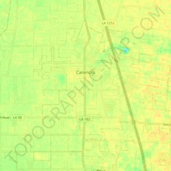
Name: Carencro topographic map, elevation, terrain.
Location: Carencro, Lafayette Parish, Louisiana, 70520, United States (30.28305 -92.07474 30.33977 -91.99012)
Average elevation: 49 ft
Minimum elevation: 0 ft
Maximum elevation: 66 ft
Lafayette Parish trails, hiking, mountain biking, running and outdoor activities
Make a donation
Gear up for your next adventure:
As an Amazon Associate, this site earns from qualifying purchases at no extra cost to you.
Other topographic maps
Click on a map to view its topography, its elevation and its terrain.
Make a donation
Gear up for your next adventure:
As an Amazon Associate, this site earns from qualifying purchases at no extra cost to you.