
Châtenay-Malabry topographic map
Interactive map
Click on the map to display elevation.
About this map
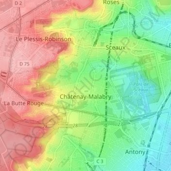
Name: Châtenay-Malabry topographic map, elevation, terrain.
Average elevation: 364 ft
Minimum elevation: 164 ft
Maximum elevation: 587 ft
Other topographic maps
Click on a map to view its topography, its elevation and its terrain.
Hameau de Bois Preau
France > Ile-de-France > Hauts-de-Seine > Rueil-Malmaison
Average elevation: 295 ft
Jardin de la Mairie
France > Ile-de-France > Hauts-de-Seine > Boulogne-Billancourt
Average elevation: 171 ft