
Fontenay-sous-Bois topographic map
Interactive map
Click on the map to display elevation.
About this map
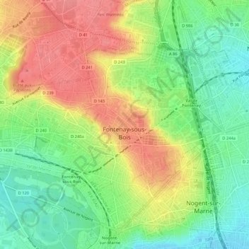
Name: Fontenay-sous-Bois topographic map, elevation, terrain.
Average elevation: 249 ft
Minimum elevation: 128 ft
Maximum elevation: 381 ft
Other topographic maps
Click on a map to view its topography, its elevation and its terrain.
Nogent-sur-Marne
France > Ile-de-France > Val-de-Marne > Nogent-sur-Marne > Nogent-sur-Marne
Average elevation: 217 ft