
Wilderness topographic map
Interactive map
Click on the map to display elevation.
About this map
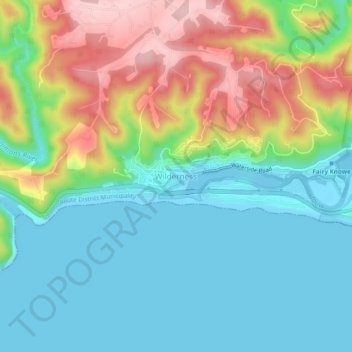
Name: Wilderness topographic map, elevation, terrain.
Average elevation: 226 ft
Minimum elevation: -10 ft
Maximum elevation: 696 ft
Other topographic maps
Click on a map to view its topography, its elevation and its terrain.
George
South Africa > Western Cape > Garden Route District Municipality > George Local Municipality
George, George Local Municipality, Garden Route District Municipality, Western Cape, 6530, South Africa
Average elevation: 801 ft
Swart River
South Africa > Western Cape > Garden Route District Municipality > George Local Municipality
Swart River, George Local Municipality, Garden Route District Municipality, Western Cape, South Africa
Average elevation: 1,122 ft
Skurwekop
South Africa > Western Cape > Garden Route District Municipality > George Local Municipality
Skurwekop, George Local Municipality, Garden Route District Municipality, Western Cape, South Africa
Average elevation: 2,785 ft
Rondekop
South Africa > Western Cape > Garden Route District Municipality > George Local Municipality
Rondekop, George Local Municipality, Garden Route District Municipality, Western Cape, South Africa
Average elevation: 1,611 ft
Skurweberg
South Africa > Western Cape > Garden Route District Municipality > George Local Municipality
Skurweberg, George Local Municipality, Garden Route District Municipality, Western Cape, South Africa
Average elevation: 3,186 ft
Garden Route Dam
South Africa > Western Cape > Garden Route District Municipality > George Local Municipality
Garden Route Dam, Glenwood, George Ward 11, George Local Municipality, Garden Route District Municipality, Western Cape, 6546, South Africa
Average elevation: 659 ft
Uniondale
South Africa > Western Cape > Garden Route District Municipality > George Local Municipality
Uniondale, George Local Municipality, Garden Route District Municipality, Western Cape, 6460, South Africa
Average elevation: 2,779 ft