
Thank you for supporting this site ❤️
Make a donation
Make a donation
Gear up for your next adventure:
As an Amazon Associate, this site earns from qualifying purchases at no extra cost to you.
George topographic map
Click on the map to display elevation.
Thank you for supporting this site ❤️
Make a donation
Make a donation
Gear up for your next adventure:
As an Amazon Associate, this site earns from qualifying purchases at no extra cost to you.
About this map
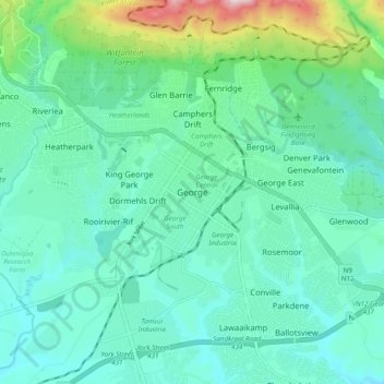
Name: George topographic map, elevation, terrain.
Average elevation: 801 ft
Minimum elevation: 453 ft
Maximum elevation: 2,215 ft
Thank you for supporting this site ❤️
Make a donation
Make a donation
Gear up for your next adventure:
As an Amazon Associate, this site earns from qualifying purchases at no extra cost to you.
Other topographic maps
Click on a map to view its topography, its elevation and its terrain.
Garden Route Dam
South Africa > Western Cape > Garden Route District Municipality > George Local Municipality
Average elevation: 659 ft
Swart River
South Africa > Western Cape > Garden Route District Municipality > George Local Municipality
Average elevation: 1,122 ft