
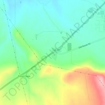
Mission Valley Historical Marker topographic map
Interactive map
Click on the map to display elevation.
About this map
Name: Mission Valley Historical Marker topographic map, elevation, terrain.
Average elevation: 2,982 ft
Minimum elevation: 2,815 ft
Maximum elevation: 3,320 ft
Other topographic maps
Click on a map to view its topography, its elevation and its terrain.
Saint Ignatius
United States > Montana > Lake County
Saint Ignatius, Lake County, Montana, 59865, United States
Average elevation: 2,930 ft
Flathead Lake
United States > Montana > Lake County
Flathead Lake, Lake County, Montana, United States
Average elevation: 3,832 ft
Polson
United States > Montana > Lake County
Polson, Lake County, Montana, United States
Average elevation: 3,048 ft
North Swan Valley Wildlife Management Area
United States > Montana > Lake County
North Swan Valley Wildlife Management Area, Lake County, Montana, United States
Average elevation: 4,039 ft
Moore Lake
United States > Montana > Lake County
Moore Lake, Lake County, Montana, United States
Average elevation: 5,925 ft
Estes Lake
United States > Montana > Lake County
Estes Lake, Lake County, Montana, United States
Average elevation: 3,504 ft
Kicking Horse
United States > Montana > Lake County
Kicking Horse, Lake County, Montana, United States
Average elevation: 3,077 ft
Big Arm
United States > Montana > Lake County
Big Arm, Lake County, Montana, 59910, United States
Average elevation: 3,491 ft