
Make a donation
Gear up for your next adventure:
As an Amazon Associate, this site earns from qualifying purchases at no extra cost to you.
Weiler ob Helfenstein topographic map
Click on the map to display elevation.
Make a donation
Gear up for your next adventure:
As an Amazon Associate, this site earns from qualifying purchases at no extra cost to you.
About this map
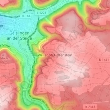
Name: Weiler ob Helfenstein topographic map, elevation, terrain.
Average elevation: 1,972 ft
Minimum elevation: 1,381 ft
Maximum elevation: 2,313 ft
Make a donation
Gear up for your next adventure:
As an Amazon Associate, this site earns from qualifying purchases at no extra cost to you.
Other topographic maps
Click on a map to view its topography, its elevation and its terrain.
Aufhausen
Deutschland > Baden-Württemberg > Landkreis Göppingen > Geislingen an der Steige
Average elevation: 2,293 ft
73312
Deutschland > Baden-Württemberg > Landkreis Göppingen > Geislingen an der Steige > Weiler ob Helfenstein
Average elevation: 2,018 ft