
Maluti-a-Phofung Local Municipality topographic map
Interactive map
Click on the map to display elevation.
About this map
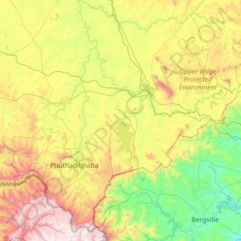
Name: Maluti-a-Phofung Local Municipality topographic map, elevation, terrain.
Average elevation: 5,686 ft
Minimum elevation: 3,389 ft
Maximum elevation: 10,768 ft
Other topographic maps
Click on a map to view its topography, its elevation and its terrain.
Golden Gate Highlands National Park
South Africa > Free State > Thabo Mofutsanyana District Municipality
The park is 320 km (200 mi) from Johannesburg and is close to the villages of Clarens and Kestell, in the upper regions of the Little Caledon River. The park is situated in the Rooiberge of the eastern Free State, in the foothills of the Maluti Mountains. The Caledon River forms the southern boundary of the…
Average elevation: 6,316 ft
Paul Roux
South Africa > Free State > Thabo Mofutsanyana District Municipality > Dihlabeng Local Municipality
Average elevation: 5,184 ft
Hobhouse
South Africa > Free State > Thabo Mofutsanyana District Municipality > Mantsopa Local Municipality
Average elevation: 4,902 ft
Bethlehem
South Africa > Free State > Thabo Mofutsanyana District Municipality > Dihlabeng Local Municipality
The city lies at an altitude of 1,700 metres (5,600 ft) and this contributes to its cool climate with frosty winters and mild summers. The average annual temperature is around 14 °C (57 °F).
Average elevation: 5,495 ft
Petrus Steyn
South Africa > Free State > Thabo Mofutsanyana District Municipality > Nketoana Local Municipality
Average elevation: 5,538 ft
Sterkfontein Dam
South Africa > Free State > Thabo Mofutsanyana District Municipality > Maluti-a-Phofung Local Municipality
Average elevation: 5,502 ft
Rainfall Dam
South Africa > Free State > Thabo Mofutsanyana District Municipality > Maluti-a-Phofung Local Municipality
Average elevation: 5,600 ft
Ficksburg
South Africa > Free State > Thabo Mofutsanyana District Municipality > Setsoto Local Municipality
Average elevation: 5,305 ft
Reitz
South Africa > Free State > Thabo Mofutsanyana District Municipality > Nketoana Local Municipality
Reitz is located in the north-eastern part of the Free State province, 300 kilometres (190 mi) north-east of Bloemfontein and 180 kilometres (110 mi) south of Johannesburg. It lies roughly halfway between the towns of Bethlehem and Frankfort, at an elevation of 1,630 metres (5,350 ft).
Average elevation: 5,407 ft
Senekal
South Africa > Free State > Thabo Mofutsanyana District Municipality > Setsoto Local Municipality
Average elevation: 4,760 ft
iNtabazwe (Harrismith)
South Africa > Free State > Thabo Mofutsanyana District Municipality > Maluti-a-Phofung Local Municipality
Average elevation: 5,630 ft
Mantsopa Ward 8
South Africa > Free State > Thabo Mofutsanyana District Municipality > Mantsopa Local Municipality
Average elevation: 5,210 ft
Phuthaditjhaba
South Africa > Free State > Thabo Mofutsanyana District Municipality > Maluti-a-Phofung Local Municipality
Average elevation: 5,696 ft