
Shoalhaven City Council topographic map
Interactive map
Click on the map to display elevation.
About this map
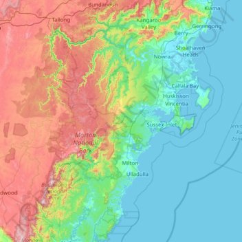
Name: Shoalhaven City Council topographic map, elevation, terrain.
Location: Shoalhaven City Council, New South Wales, Australia (-35.64462 149.97730 -34.63906 150.84991)
Average elevation: 892 ft
Minimum elevation: -10 ft
Maximum elevation: 3,638 ft
Other topographic maps
Click on a map to view its topography, its elevation and its terrain.
Sydney
Phillip had been given no instructions for urban development, but in July 1788 submitted a plan for the new town at Sydney Cove. It included a wide central avenue, a permanent Government House, law courts, hospital and other public buildings, but no provision for warehouses, shops, or other commercial…
Average elevation: 105 ft
Blue Mountains
A sandstone plateau dominated by a landscape of endless eucalyptus forests, the Blue Mountains are located at the top of a 470-million-year-old quartzite. In the Permian period, a shallow sea covered the region, when rivers brought shales, siltstones and mudstones. Then during the Mesozoic period, rivers…
Average elevation: 1,857 ft
Hawkesbury Panorama Reserve
Australia > New South Wales > Sydney > Hawkesbury Heights
Average elevation: 456 ft
Mona Vale Beach Foreshore Reserve
Australia > New South Wales > Sydney > Mona Vale
Average elevation: 30 ft
Mount Kembla
Australia > New South Wales > Wollongong
The summit of Mount Kembla has an elevation of 534 metres (1,752 ft) above sea level.
Average elevation: 745 ft
Wolongong Hill
Australia > New South Wales > Lachlan Shire Council > Condobolin
Average elevation: 653 ft