
Make a donation
Gear up for your next adventure:
As an Amazon Associate, this site earns from qualifying purchases at no extra cost to you.
Terrain topographic map
Click on the map to display elevation.
Gear up for your next adventure:
As an Amazon Associate, this site earns from qualifying purchases at no extra cost to you.
About this map
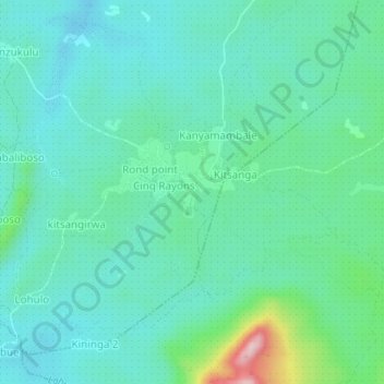
Name: Terrain topographic map, elevation, terrain.
Location: Terrain, Beni, North Kivu, Democratic Republic of the Congo (0.39287 29.27203 0.43287 29.31203)
Average elevation: 3,556 ft
Minimum elevation: 3,376 ft
Maximum elevation: 4,272 ft
Make a donation
Gear up for your next adventure:
As an Amazon Associate, this site earns from qualifying purchases at no extra cost to you.
Other topographic maps
Click on a map to view its topography, its elevation and its terrain.
Mount Stanely
Democratic Republic of the Congo > North Kivu > Beni
Mount Stanley, also known as Mount Ngaliema (/əŋɡɑːˈljeɪmə/, also US: /-mɑː/, UK: /əŋˌɡɑːliˈeɪmə/), is a mountain located in the Rwenzori range. With an elevation of 5,109 m (16,763 ft), it is the highest mountain of both the Democratic Republic of the Congo and Uganda, and the fourth-highest in Africa.
Average elevation: 13,694 ft
Mount Stanely
Democratic Republic of the Congo > North Kivu > Beni
Mount Stanley, also known as Mount Ngaliema (/əŋɡɑːˈljeɪmə/, also US: /-mɑː/, UK: /əŋˌɡɑːliˈeɪmə/), is a mountain located in the Rwenzori range. With an elevation of 5,109 m (16,763 ft), it is the highest mountain of both the Democratic Republic of the Congo and Uganda, and the third highest…
Average elevation: 13,694 ft