
Secaucus topographic map
Interactive map
Click on the map to display elevation.
About this map
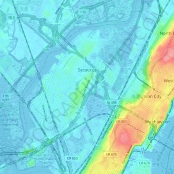
Name: Secaucus topographic map, elevation, terrain.
Location: Secaucus, Hudson County, New Jersey, United States (40.74905 -74.09496 40.80770 -74.03302)
Average elevation: 43 ft
Minimum elevation: -16 ft
Maximum elevation: 262 ft
Hudson County trails, hiking, mountain biking, running and outdoor activities
Other topographic maps
Click on a map to view its topography, its elevation and its terrain.
Marion
United States > New Jersey > Hudson County > Jersey City > Journal Square
Average elevation: 39 ft
Hudson River Waterfront
United States > New Jersey > Hudson County > Jersey City
Average elevation: 7 ft
North End Business District
United States > New Jersey > Hudson County > Secaucus
Average elevation: 13 ft