
Springboro topographic map
Interactive map
Click on the map to display elevation.
About this map
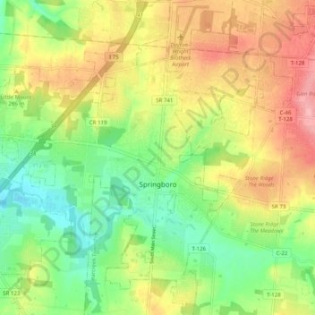
Name: Springboro topographic map, elevation, terrain.
Location: Springboro, Warren County, Ohio, 45066, United States (39.52063 -84.27600 39.59685 -84.19103)
Average elevation: 863 ft
Minimum elevation: 689 ft
Maximum elevation: 1,070 ft
Warren County trails, hiking, mountain biking, running and outdoor activities
Other topographic maps
Click on a map to view its topography, its elevation and its terrain.
Corwin M. Nixon Pine Hill Lakes Park
United States > Ohio > Warren County > Mason
Average elevation: 820 ft