
Village Mont-Valérien topographic map
Interactive map
Click on the map to display elevation.
About this map
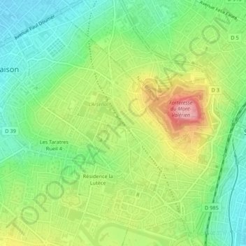
Name: Village Mont-Valérien topographic map, elevation, terrain.
Average elevation: 276 ft
Minimum elevation: 95 ft
Maximum elevation: 545 ft
Other topographic maps
Click on a map to view its topography, its elevation and its terrain.
Square Roger Jourdain
France > Île-de-France > Hauts-de-Seine > Rueil-Malmaison
Average elevation: 253 ft
Étang de Saint-Cucufa
France > Île-de-France > Hauts-de-Seine > Rueil-Malmaison
Average elevation: 446 ft
Hameau de Bois Preau
France > Île-de-France > Hauts-de-Seine > Rueil-Malmaison
Average elevation: 295 ft
Résidence la Lutèce
France > Île-de-France > Hauts-de-Seine > Rueil-Malmaison
Average elevation: 289 ft
Résidence Castellina
France > Île-de-France > Hauts-de-Seine > Rueil-Malmaison
Average elevation: 164 ft