
Shurugwi topographic map
Interactive map
Click on the map to display elevation.
About this map
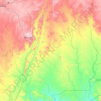
Name: Shurugwi topographic map, elevation, terrain.
Location: Shurugwi, Midlands Province, Zimbabwe (-20.07842 29.78543 -19.42935 30.48827)
Average elevation: 3,878 ft
Minimum elevation: 3,022 ft
Maximum elevation: 5,108 ft
Other topographic maps
Click on a map to view its topography, its elevation and its terrain.
Kwekwe
Zimbabwe > Midlands Province > Kwekwe
Kwekwe, Midlands Province, Zimbabwe
Average elevation: 3,937 ft
Gweru
Zimbabwe > Midlands Province > Gweru
Gweru, Midlands Province, Zimbabwe
Average elevation: 4,583 ft