
Milpa Alta topographic map
Interactive map
Click on the map to display elevation.
Milpa Alta
It has an average altitude of 2,420 meters above sea level with altitudes varying between 2,300 and 3,600. It is part of the Trans-Mexican Volcanic Belt and the Sierra Chichinautzin volcanic mountain chain, which separates Mexico City from the state of Morelos. The borough is divided into three zones: Ajusco-Teuhtli, the lowest elevations, Topilejo-Milpa Alta in the medium range and Cerro-Tlicuaya at the highest elevations. The main elevations are volcanic and include Cuautzin (3,510), Tulmiac, Ocusacayo (3,220), La Comalera (3,230), San Bartolo (3,200), Tláloc (3,510), Chichinautzin (3,470), Yecahuazac, Quimixtepec, El Oclayuca (3,140), El Pajonal (3,100), El Ocotécatl (3,480), Acopiaxco (3,320), Tetzacoatl (3,310), Tehutli (2,800) Cilcuayo (3,580), Nepanapa (3,460), Texalo (3,560), Oclayuca (3,390), San Miguel (2,988) .
About this map
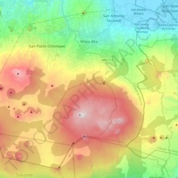
Name: Milpa Alta topographic map, elevation, terrain.
Location: Milpa Alta, Mexico City, Mexico (19.04872 -99.16329 19.22770 -98.95239)
Average elevation: 9,324 ft
Minimum elevation: 7,316 ft
Maximum elevation: 12,051 ft
Other topographic maps
Click on a map to view its topography, its elevation and its terrain.
Xochimilco
Much of the borough's land is former lakebed. Its main elevations include Xochitepec and Tlacualleli mountains along with two volcanoes named Teutli and Tzompol. It contains two natural rivers called Santiago and Tepapantla along with the various canals, which is what is left of the lake. The elevated areas of…
Average elevation: 7,352 ft