
Flag topographic map
Interactive map
Click on the map to display elevation.
About this map
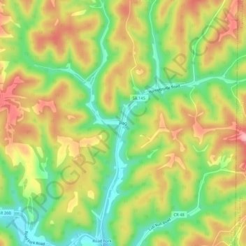
Name: Flag topographic map, elevation, terrain.
Location: Flag, Noble County, Ohio, 43786, United States (39.66646 -81.32484 39.70646 -81.28484)
Average elevation: 912 ft
Minimum elevation: 676 ft
Maximum elevation: 1,155 ft
Other topographic maps
Click on a map to view its topography, its elevation and its terrain.
Caldwell
United States > Ohio > Noble County
Caldwell, Noble County, Ohio, United States
Average elevation: 810 ft
Batesville
United States > Ohio > Noble County
Batesville, Noble County, Ohio, United States
Average elevation: 1,010 ft
Belle Valley
United States > Ohio > Noble County > Belle Valley
Belle Valley, Noble County, Ohio, 43717, United States
Average elevation: 823 ft
Mount Zion
United States > Ohio > Noble County > Mount Zion
Mount Zion, Noble County, Ohio, 43772, United States
Average elevation: 899 ft