
Burnie topographic map
Interactive map
Click on the map to display elevation.
About this map
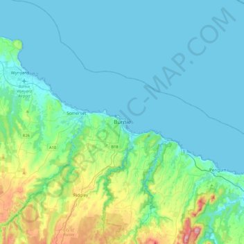
Name: Burnie topographic map, elevation, terrain.
Location: Burnie, Tasmania, 7320, Australia (-41.21237 145.74641 -40.89237 146.06641)
Average elevation: 315 ft
Minimum elevation: 0 ft
Maximum elevation: 2,116 ft
Other topographic maps
Click on a map to view its topography, its elevation and its terrain.
Chasm Creek
Australia > Tasmania > Burnie > Chasm Creek
Chasm Creek, Burnie, City of Burnie, Tasmania, Australia
Average elevation: 161 ft
Mount Everett
Mount Everett, Burnie, Tasmania, 7320, Australia
Average elevation: 2,224 ft