
Distrito Las Palmas topographic map
Interactive map
Click on the map to display elevation.
About this map
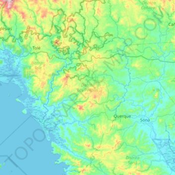
Name: Distrito Las Palmas topographic map, elevation, terrain.
Location: Distrito Las Palmas, Veraguas, Panama (7.83049 -81.68315 8.39870 -81.36223)
Average elevation: 571 ft
Minimum elevation: -10 ft
Maximum elevation: 3,596 ft
Other topographic maps
Click on a map to view its topography, its elevation and its terrain.