
Plainfield topographic map
Interactive map
Click on the map to display elevation.
About this map
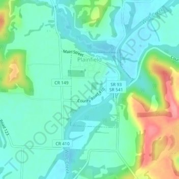
Name: Plainfield topographic map, elevation, terrain.
Location: Plainfield, Coshocton County, Ohio, 43836, United States (40.19921 -81.72340 40.21074 -81.71085)
Average elevation: 820 ft
Minimum elevation: 735 ft
Maximum elevation: 1,050 ft
Coshocton County trails, hiking, mountain biking, running and outdoor activities
Other topographic maps
Click on a map to view its topography, its elevation and its terrain.