
Fulton topographic map
Interactive map
Click on the map to display elevation.
About this map
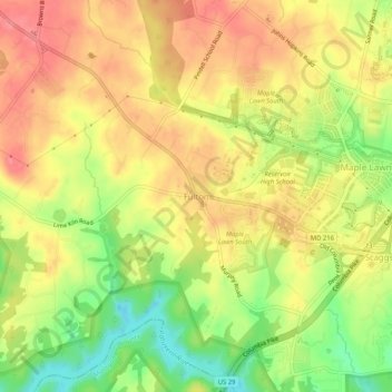
Name: Fulton topographic map, elevation, terrain.
Location: Fulton, Howard County, Maryland, 20759, United States (39.13094 -76.94303 39.17094 -76.90303)
Average elevation: 417 ft
Minimum elevation: 259 ft
Maximum elevation: 531 ft
Howard County trails, hiking, mountain biking, running and outdoor activities
Other topographic maps
Click on a map to view its topography, its elevation and its terrain.
Patapsco Valley State Park
United States > Maryland > Howard County > Ilchester
Average elevation: 430 ft