
Eaton Rapids topographic map
Interactive map
Click on the map to display elevation.
About this map
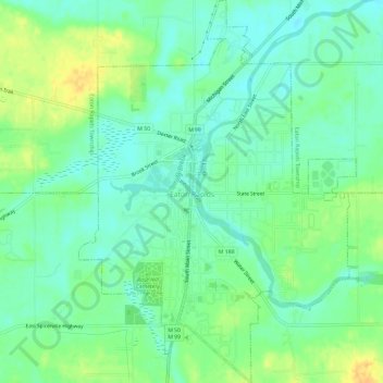
Name: Eaton Rapids topographic map, elevation, terrain.
Location: Eaton Rapids, Eaton County, Michigan, 48827, United States (42.48798 -84.67308 42.53092 -84.63060)
Average elevation: 892 ft
Minimum elevation: 856 ft
Maximum elevation: 948 ft
Eaton County trails, hiking, mountain biking, running and outdoor activities
Other topographic maps
Click on a map to view its topography, its elevation and its terrain.
Grand Ledge
United States > Michigan > Eaton County > Grand Ledge > Grand Ledge
Average elevation: 850 ft