
Gladstone topographic map
Interactive map
Click on the map to display elevation.
About this map
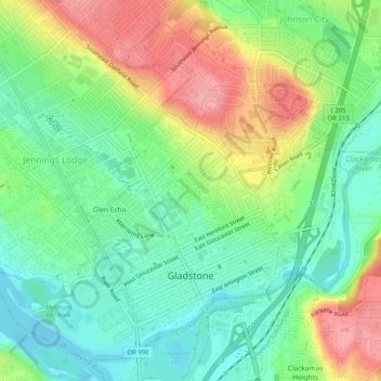
Name: Gladstone topographic map, elevation, terrain.
Location: Gladstone, Clackamas County, Oregon, 97027, United States (45.37229 -122.62035 45.40418 -122.56958)
Average elevation: 135 ft
Minimum elevation: -7 ft
Maximum elevation: 341 ft
Clackamas County trails, hiking, mountain biking, running and outdoor activities
Other topographic maps
Click on a map to view its topography, its elevation and its terrain.
Sherwood Forest Tot Lot
United States > Oregon > Clackamas County > Gladstone
Average elevation: 210 ft
Wilhoit Springs County Park
United States > Oregon > Clackamas County > Wilhoit
Average elevation: 1,033 ft