
Blaustein topographic map
Interactive map
Click on the map to display elevation.
About this map
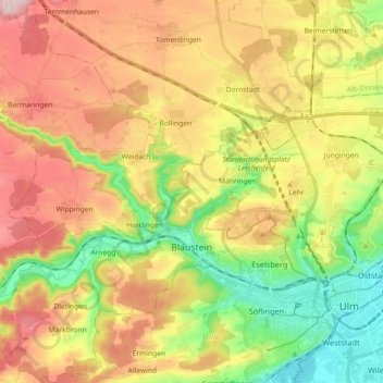
Name: Blaustein topographic map, elevation, terrain.
Location: Blaustein, Alb-Donau-Kreis, Baden-Württemberg, 89134, Germany (48.37302 9.79758 48.49346 9.94277)
Average elevation: 1,916 ft
Minimum elevation: 1,522 ft
Maximum elevation: 2,349 ft
Blaustein is west from Ulm, nestled between Hochsträß, Blautal, Lautertal and the plateau of the Swabian Jura. The town lies at an altitude of 490-690 meters. The rivers Blau and Lauter – which arises in Blaustein (Lautern) – flow through the city.
Other topographic maps
Click on a map to view its topography, its elevation and its terrain.
Erbach
Germany > Baden-Württemberg > Alb-Donau-Kreis
Erbach, Alb-Donau-Kreis, Baden-Württemberg, 89155, Germany
Average elevation: 1,693 ft
Langenau
Germany > Baden-Württemberg > Alb-Donau-Kreis
Langenau, GVV Langenau, Alb-Donau-Kreis, Baden-Württemberg, 89129, Germany
Average elevation: 1,627 ft
Illerkirchberg
Germany > Baden-Württemberg > Alb-Donau-Kreis
Illerkirchberg, Gemeindeverwaltungsverband Kirchberg-Weihungstal, Alb-Donau-Kreis, Baden-Württemberg, 89171, Germany
Average elevation: 1,650 ft