
East Kilbride topographic map
Interactive map
Click on the map to display elevation.
East Kilbride
The earliest known evidence of occupation in the area dates as far back as the late Neolithic and Early Bronze Age, as archaeological investigation has demonstrated that burial cairns in the district began as ceremonial or ritual sites of burial during the Neolithic, with the use of cup-marked, and other inscribed stones at key elevated sites, only to be later built upon with earth and re-used for burial into the Bronze Age. These findings have found further support through ongoing research indicating that many East Kilbride Cairns first noticed by the Reverend David Ure in his History of Rutherglen and East Kilbride (1793), are embedded, alongside other monuments, into a ritual landscape related to ancestor cults and relationships with key topographical features and annual solar events. A flint arrow head was discovered by Allan Forrest, a then child resident whilst groundworks were taking place in his family's garden at Glen Bervie, St Leonards in 1970 which later was identified as dating to 1500 BC (Bronze Age). Ancient graves have also been found near the Kype Water to the south of the town near Strathaven, and Roman coins, lamps, and footwear have also been found in the area.
About this map
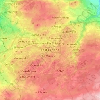
Name: East Kilbride topographic map, elevation, terrain.
Average elevation: 571 ft
Minimum elevation: 151 ft
Maximum elevation: 846 ft