
Peachtree City topographic map
Interactive map
Click on the map to display elevation.
Peachtree City
Shakerag Hill, with an elevation of 980 feet (300 m), is the highest point in the city and sits on the eastern border at the intersection of GA Hwy 54 and Robinson Road.
About this map
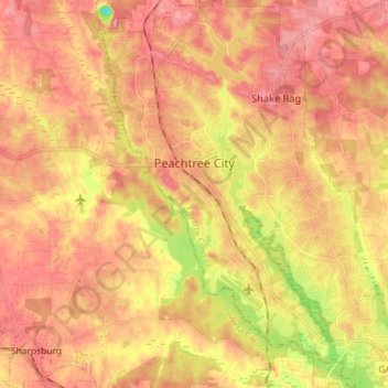
Name: Peachtree City topographic map, elevation, terrain.
Average elevation: 860 ft
Minimum elevation: 591 ft
Maximum elevation: 1,014 ft
Fayette County trails, hiking, mountain biking, running and outdoor activities
Other topographic maps
Click on a map to view its topography, its elevation and its terrain.
Tamerlane
United States > Georgia > Fayette County > Peachtree City > Tamerlane
Average elevation: 810 ft