
Chelsea topographic map
Interactive map
Click on the map to display elevation.
About this map
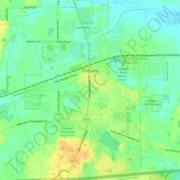
Name: Chelsea topographic map, elevation, terrain.
Location: Chelsea, Washtenaw County, Michigan, 48118, United States (42.29453 -84.03923 42.33309 -83.99744)
Average elevation: 919 ft
Minimum elevation: 879 ft
Maximum elevation: 971 ft
Washtenaw County trails, hiking, mountain biking, running and outdoor activities
Other topographic maps
Click on a map to view its topography, its elevation and its terrain.