
Roberts topographic map
Interactive map
Click on the map to display elevation.
About this map
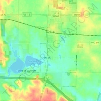
Name: Roberts topographic map, elevation, terrain.
Location: Roberts, Saint Croix County, Wisconsin, United States (44.94916 -92.57847 44.99993 -92.53753)
Average elevation: 1,027 ft
Minimum elevation: 955 ft
Maximum elevation: 1,145 ft
Saint Croix County trails, hiking, mountain biking, running and outdoor activities
Other topographic maps
Click on a map to view its topography, its elevation and its terrain.
Mount Hellen
United States > Wisconsin > Saint Croix County > Town of Saint Joseph
Average elevation: 925 ft