
Bristol Township topographic map
Interactive map
Click on the map to display elevation.
About this map
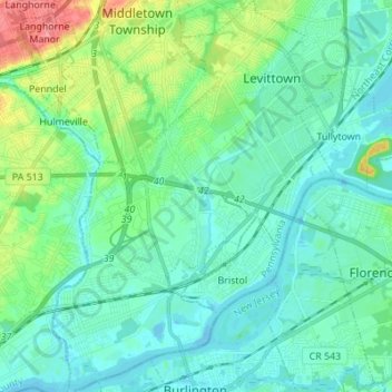
Name: Bristol Township topographic map, elevation, terrain.
Location: Bristol Township, Bucks County, Pennsylvania, United States (40.07055 -74.91484 40.17548 -74.81570)
Average elevation: 52 ft
Minimum elevation: -26 ft
Maximum elevation: 243 ft
Bucks County trails, hiking, mountain biking, running and outdoor activities
Other topographic maps
Click on a map to view its topography, its elevation and its terrain.
Langhorne Gardens
United States > Pennsylvania > Bucks County > Middletown Township
Average elevation: 148 ft
Blue Ridge
United States > Pennsylvania > Bucks County > Bristol Township > Levittown
Average elevation: 52 ft
Southampton
United States > Pennsylvania > Bucks County > Upper Southampton Township
Average elevation: 246 ft
Southampton
United States > Pennsylvania > Bucks County > Upper Southampton Township
Average elevation: 246 ft
Taylorsville
United States > Pennsylvania > Bucks County > Upper Makefield Township > Washington Crossing
Average elevation: 121 ft
Woodbourne
United States > Pennsylvania > Bucks County > Middletown Township
Average elevation: 157 ft
Blooming Glen
United States > Pennsylvania > Bucks County > Hilltown Township
Average elevation: 430 ft
Blue Ridge
United States > Pennsylvania > Bucks County > Bristol Township > Levittown
Average elevation: 52 ft
Bridge Point
United States > Pennsylvania > Bucks County > Doylestown Township
Average elevation: 269 ft
Eddington Gardens
United States > Pennsylvania > Bucks County > Bensalem Township > Eddington Gardens
Average elevation: 95 ft
Kintnersville
United States > Pennsylvania > Bucks County > Nockamixon Township
Average elevation: 371 ft
Croydon
United States > Pennsylvania > Bucks County > Bristol Township > Croydon
Average elevation: 26 ft
Red Cedar Hill
United States > Pennsylvania > Bucks County > Bristol Township > Levittown > Red Cedar Hill
Average elevation: 69 ft