Geolocate

Browns Lake/IPS Wildlife Management Area topographic map

Interactive map

Click on the map to display elevation.

About this map

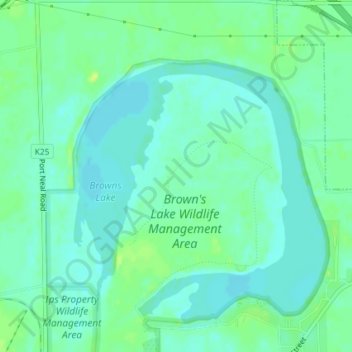
Name: Browns Lake/IPS Wildlife Management Area topographic map, elevation, terrain.

Location: Browns Lake/IPS Wildlife Management Area, Woodbury County, Iowa, 51052, United States of America (42.31661 -96.33508 42.31671 -96.33498)

Average elevation: 1,076 ft

Minimum elevation: 1,056 ft

Maximum elevation: 1,109 ft

Other topographic maps

Click on a map to view its topography, its elevation and its terrain.

Glenwood

United States of America > Iowa > Glenwood

Glenwood, Mills County, Iowa, 51534, United States of America

Average elevation: 1,073 ft

Key West

United States of America > Iowa > Key West

Key West, Dubuque County, Iowa, 52003, United States of America

Average elevation: 764 ft

Osborne

United States of America > Iowa > Osborne

Osborne, Clayton County, Iowa, United States of America

Average elevation: 883 ft

Volga River

United States of America > Iowa

Volga River, Clayton County, Iowa, 52055, United States of America

Average elevation: 879 ft

Montezuma

United States of America > Iowa > Montezuma

Montezuma, Poweshiek County, Iowa, 50171, United States of America

Average elevation: 932 ft

Inwood

United States of America > Iowa > Inwood

Inwood, Lyon County, Iowa, United States of America

Average elevation: 1,457 ft

Durant

United States of America > Iowa > Durant

Durant, Cedar County, Iowa, 552747, United States of America

Average elevation: 705 ft

Griswold

United States of America > Iowa > Griswold

Griswold, Cass County, Iowa, United States of America

Average elevation: 1,102 ft

Milton

United States of America > Iowa > Milton

Milton, Iowa, United States of America

Average elevation: 784 ft

Hartwick

United States of America > Iowa > Hartwick > Hartwick

Hartwick, Poweshiek County, Iowa, 52232, United States of America

Average elevation: 912 ft

Burr Oak

United States of America > Iowa > Burr Oak > Burr Oak

Burr Oak, Winneshiek County, Iowa, United States of America

Average elevation: 1,260 ft