
Village of Sharon Springs topographic map
Interactive map
Click on the map to display elevation.
About this map
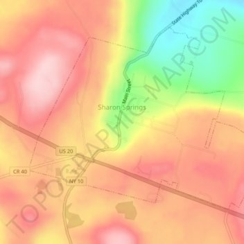
Name: Village of Sharon Springs topographic map, elevation, terrain.
Average elevation: 1,293 ft
Minimum elevation: 866 ft
Maximum elevation: 1,555 ft
Schoharie County trails, hiking, mountain biking, running and outdoor activities
Other topographic maps
Click on a map to view its topography, its elevation and its terrain.
Grovenor Corners
United States > New York > Schoharie County > Town of Carlisle
Average elevation: 1,099 ft
Charlotteville
United States > New York > Schoharie County > Town of Summit
Average elevation: 1,850 ft
Huntersland
United States > New York > Schoharie County > Town of Middleburgh
Average elevation: 1,549 ft
Mine Kill State Park
United States > New York > Schoharie County > Town of Gilboa
Average elevation: 1,155 ft
Old Central Bridge
United States > New York > Schoharie County > Town of Schoharie > Old Central Bridge
Average elevation: 810 ft