
Haslemere topographic map
Interactive map
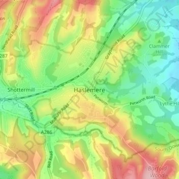
Click on the map to display elevation.
Haslemere
Elevations range between, in fully developed roads, 205m AOD to 97m and 112m AOD alongside respectively the east and west streams which forms an east-west steep valley through the parish almost meeting in the town centre. This lowest point is specifically in the north east, where one headwater gently curves north following the line of the railway past the north of Grayswood, however rapidly descends another 40m in the space of a few miles. This east stream is the longest headwater of the River Arun/ˈærʊn/ then passing the north of Chiddingfold and turning south close to in the village centre of Dunsfold. By contrast the west stream, the River Wey south branch flows around Headley and past Frensham Common, joins the north branch in the centre of Tilford and heads towards Guildford before reaching the River Thames. However across the north and the south, the wooded hillsides reach 272m at Gibbet Hill in the north and 204m, AOD 211m on Marley Common south of Camelsdale and 280 on Black Down rising gradually across the county line in West Sussex.
About this map
Name: Haslemere topographic map, elevation, terrain.
Average elevation: 538 ft
Minimum elevation: 299 ft
Maximum elevation: 869 ft