
Columbus topographic map
Interactive map
Click on the map to display elevation.
About this map
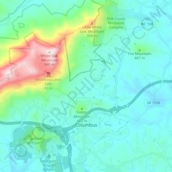
Name: Columbus topographic map, elevation, terrain.
Location: Columbus, Polk County, North Carolina, United States (35.23478 -82.21909 35.30159 -82.17634)
Average elevation: 1,332 ft
Minimum elevation: 909 ft
Maximum elevation: 3,035 ft
Polk County trails, hiking, mountain biking, running and outdoor activities
Other topographic maps
Click on a map to view its topography, its elevation and its terrain.