
Holly Park topographic map
Interactive map
Click on the map to display elevation.
About this map
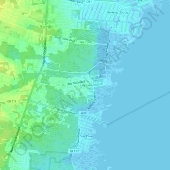
Name: Holly Park topographic map, elevation, terrain.
Average elevation: 13 ft
Minimum elevation: -13 ft
Maximum elevation: 59 ft
Ocean County trails, hiking, mountain biking, running and outdoor activities
Other topographic maps
Click on a map to view its topography, its elevation and its terrain.
Holiday Heights
United States > New Jersey > Ocean County > Berkeley Township
Average elevation: 52 ft
Island Beach State Park
United States > New Jersey > Ocean County > Berkeley Township
Average elevation: 3 ft