
Franklin topographic map
Interactive map
Click on the map to display elevation.
Franklin
Franklin is characterized by its mountainous terrain, lying within the picturesque Appalachian Mountains. The area features rugged landscapes with elevations typically ranging from around 2,000 to 4,000 feet, creating dramatic vistas and deep valleys. The Little Tennessee River winds through the region, adding to the topographical variety. The hillsides are often cloaked in dense forests, while several prominent waterfalls, including Dry Falls, enhance the area's natural beauty. This diverse topography supports a range of outdoor activities, from hiking and fishing to gemstone hunting.
About this map
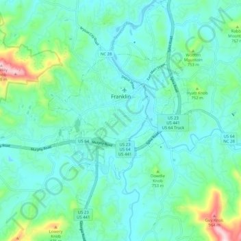
Name: Franklin topographic map, elevation, terrain.
Location: Franklin, Macon County, North Carolina, 28734, United States (35.13238 -83.43950 35.21556 -83.35178)
Average elevation: 2,215 ft
Minimum elevation: 1,962 ft
Maximum elevation: 3,323 ft
Macon County trails, hiking, mountain biking, running and outdoor activities
Other topographic maps
Click on a map to view its topography, its elevation and its terrain.
Highlands
United States > North Carolina > Macon County > Highlands
Highlands was founded in 1875 after its two founders, Samuel Truman Kelsey and Clinton Carter Hutchinson, drew lines from Chicago to Savannah and from New Orleans to New York City. They felt that the place where these lines met would eventually become a great trading center and commercial crossroads. Highlands…
Average elevation: 3,576 ft
Franklin
United States > North Carolina > Macon County > Franklin
Franklin is located at 35°10′52″N 83°22′54″W / 35.18111°N 83.38167°W / 35.18111; -83.38167 (35.181144, -83.381685). The elevation of Franklin is 2119 ft.
Average elevation: 2,182 ft